
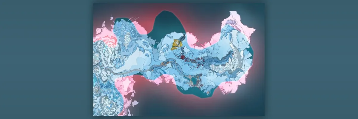
A newly circulated Genshin Impact Version 7.2 map image gives a different look at the proposed snowy expansion: irregular bright pink patches appear around several outer edges of the pale blue terrain. The material is leaked, and its surrounding discussion describes those shapes as a possible Paimon boundary. The image itself does not label them or show how they behave during play.
What the new image shows
The central landmass stretches horizontally across dark blue water or an unfilled map background. Most of it is rendered in light blue and white, with ridges, branching paths and built-up areas visible at this scale. A winding line crosses much of the lower half toward a compact cluster of structures near the southern edge. Toward the east stands a large pale formation whose shape recalls the wing-like landmark named in earlier reports; that resemblance is not a printed map label.
The new point of interest is the edge treatment. Pink appears in uneven bands along portions of the northern side, in broad patches below the center and at the eastern and western extremes. Some of the pink sections overlap or sit immediately beside pale blue terrain rather than forming one continuous line. A darker gap occupies part of the upper middle. The picture provides a useful overview of these color regions, but no legend explains what either color denotes.
An earlier leaked overview had already shown a broad frozen map, a curved route, an eastern pale formation and coastal structures. GamesAndChill covered that general geography and later reported a separate list of possible subareas around Novokitezhgrad. This image does not become new merely because it shows the same snowfield again. Its additional visible detail is the pink fringe surrounding several sides of the map, which creates a distinct question about how this version of the area is represented.
Why a colored edge is not yet a gameplay boundary
A Paimon boundary would affect where the Traveler can move, but a static image cannot demonstrate that interaction. It contains no gameplay footage of Paimon turning the player back, no coordinates and no legend marking an accessible limit. The pink regions might be a test-build overlay, unfinished terrain, an out-of-bounds indicator or some other map layer. Those are possibilities, not facts established by the picture. It would be premature to outline the playable region by tracing the pink shapes.
The image also does not say whether its blue landmass is a single surface layer, a composite of several map levels or a final version of the in-game map. The gold-colored feature near the upper center and the red markings across part of the middle remain unlabeled. Likewise, visible structures near the lower coast should not be assigned to Novokitezhgrad, Puerto Belovodye or any other named area without a map key.
For exploration-minded players, the worthwhile update is visual rather than mechanical: the new image displays the proposed region's margins more clearly than the earlier overview and shows that the pink treatment is not limited to one corner. It gives a stronger reference for comparing later maps, while leaving the question of traversable space open. HoYoverse has not announced this Version 7.2 map or confirmed what the colors mean. Any boundary claim and the terrain's final shape remain subject to change.