
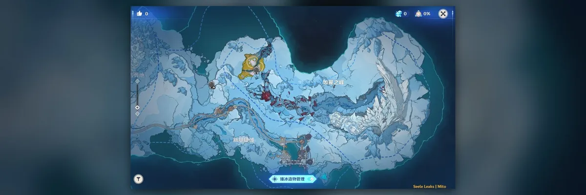
A leaked Genshin Impact Version 7.2 map places Chinese labels for Wingspan Peak and Novokitezhgrad on a snowy landmass. A second view of the same broad area now overlays it with many small, waypoint-style markers, making the proposed region easier to examine without establishing exactly what every symbol does. Alongside the map images, a separate SaveTeyvat-related screen shows a selection of six nations. All three visuals come from unreleased material and may change before HoYoverse announces Version 7.2.
The labeled map is a horizontal sweep of pale snow and blue-gray rock, with dark water or empty map space along its edges. A winding route crosses the lower half toward structures on the southern coast. Red markings run through the center; a small golden patch sits farther northwest. The tall, pale formation in the east remains the most striking landmark, but the readable location text makes this view more useful than earlier unlabeled overviews.
Where the names sit on the map
The Chinese text corresponding to Wingspan Peak appears in the eastern half of the landmass, to the left of the feather-like white formation. Novokitezhgrad sits much farther southwest, above the southern shoreline and to the left of the built-up coastal cluster. That places the two names in separate general areas of the image; it does not draw boundaries around either location or show where one named district ends and another begins.
An earlier leaked area list named both places and also mentioned smaller sites, including a railway station, a refinery and a port. The labeled map does not print those smaller names at readable points. It would be tempting to identify a particular coastal structure as Port Belovodye or a point on the route as the railway station, but neither assignment follows from the two visible labels. The city and peak names are the evidence here, not a complete guide to every building.
The second view adds a layer of markers
The newer map image shows the same broad snowy terrain beneath numerous small, teardrop-shaped symbols. They extend from the western route and northern snowfield through the red-toned central area to the pale formation in the east. Others appear around the southern structures. This is a meaningful visual change from the name-focused map: readers can now see how the symbols are distributed around landmarks rather than only where the two labels appear.